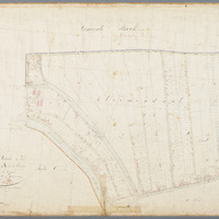
Kadastrale kaart (minuutplan) Gouda, sectie A, blad 02 (1811-1832)
Kadastrale kaart 1811-1832: minuutplan Gouda, Zuid Holland, sectie A, blad 02
sdo:associatedMedia →
<n247e89a70e424c4da701579a313fa46bb2>


geo:hasGeometry →
<n247e89a70e424c4da701579a313fa46bb1>
|
geo:as |
LINESTRING see map — or expand"LINESTRING (4.7099651 52.0172032,4.7099598 52.0180672,4.7171347 52.0186029,4.7217822 52.0186494,4.7227235 52.015034,4.7211004 52.0145578,4.7176141 52.0139097,4.7159324 52.0133703,4.7156401 52.0134864,4.7152414 52.0134994,4.7138278 52.0144446,4.7122337 52.0153039,4.7104786 52.0159857,4.7101317 52.0160275,4.7099651 52.0172032)"^^geo:wktLiteral |