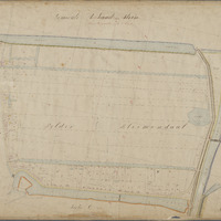
Kadastrale kaart (minuutplan) Gouda, sectie A, blad 03 (1811-1832)
Kadastrale kaart 1811-1832: minuutplan Gouda, Zuid Holland, sectie A, blad 03
sdo:associatedMedia →
<n655e178426cf4f90a66183a1e2439abab2>


geo:hasGeometry →
<n655e178426cf4f90a66183a1e2439abab1>
|
geo:as |
LINESTRING see map — or expand"LINESTRING (4.7159324 52.0133703,4.7176141 52.0139097,4.7211004 52.0145578,4.7227235 52.015034,4.724703 52.0074303,4.722641 52.0072389,4.7202903 52.0070206,4.7169321 52.0074183,4.7160062 52.0074485,4.7162127 52.0082874,4.7154996 52.0124397,4.7159403 52.0126996,4.71622 52.0131781,4.7159324 52.0133703)"^^geo:wktLiteral |