|
sdo:name
|
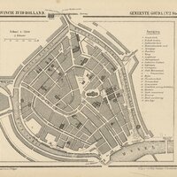
"Gemeente-Atlas van Nederland naar officieele bronnen bewerkt, Gouda (1865-1870)"@nl
|
|
owl:sameAs
|
<https://www.goudatijdmachine.nl/omeka/api/items/13>
|
|
rdfs:seeAlso
|
wd:Q1385091
|
|
o:created
|
"2021-07-03T21:17:24+00:00"^^xsd:dateTime
|
|
o:id
|
13
|
|
o:is_public
|
"true"^^xsd:boolean
|
|
o:item_set
|
Goudse kaarten, plattegronden en stadsgezichten
|
|
o:media
|
<https://www.goudatijdmachine.nl/omeka/api/media/14>
|
|
o:owner
|
<https://www.goudatijdmachine.nl/omeka/api/users/2>
|
|
o:primary_media
|
<https://www.goudatijdmachine.nl/omeka/api/media/14>
|
|
o:resource_class
|
<https://www.goudatijdmachine.nl/omeka/api/resource_classes/386>
|
|
o:resource_template
|
<https://www.goudatijdmachine.nl/omeka/api/resource_templates/4>
|
|
o:site
|
<https://www.goudatijdmachine.nl/omeka/api/sites/2>
|
|
o:title
|
"Gemeente-Atlas van Nederland naar officieele bronnen bewerkt, Gouda (1865-1870)"
|
|
sdo:associatedMedia
|
<https://www.goudatijdmachine.nl/omeka/iiif/3/13/manifest>
|
|
<n71a534131c5f42a0876aa13185eabda6b1>
|
|
sdo:collection
|
<https://www.nationaalarchief.nl/onderzoeken/zoeken?activeTab=map_legacy>
|
|
sdo:identifier
|
"Nummer toegang 4.EKR, inventarisnummer 34D"
|
|
sdo:locationCreated
|
Gouda
|
|
sdo:publisher
|
Nationaal Archief
|
|
sdo:sdDatePublished
|
"2026-06-23T18:42:14+00:00"^^xsd:dateTime
|
|
sdo:url
|
<https://www.nationaalarchief.nl/onderzoeken/zoeken?activeTab=maps&rm=gallery>
|